Birger Lundgren
Cape Town, South Africa
Let’s Talk Sh*t
What if one of the biggest climate and health solutions on Earth is something we have all been sitting on for centuries? The toilet.


Hello Bloom! In hopes of conveying some idea of the character, needs of our local landscape, figured I'd review some of the watersheds we've been scouting for 2024 landscape rehydration work.
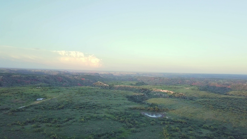
Cedar Creek, NW Potter County
Groundwater discharges from base of high plains aquifer system at head of canyon(s). Problems due land use history where significant fragile prairie topsoils overlie (& hold together) weak mineral layers - eventually badlands form with essentially no vegetative cover or organic soil formation, further increases runoff... A positive feedback loop that increases magnitude of degradation event :/
Issues include highly mineralized surficial geology (complex biogeochem), extreme sediment flux, difficult access & availability of materials. We (Ogallala Life) reviewed this site & would like to conduct landscape rehydration work here but need focus on lower-hanging fruit, to achieve visible successes in recovering watershed function - of such critical importance in semi arid regions like ours. Pretty country.

W. Amarillo Creek, Wildcat Bluff, Potter County TX
We are in midst of conversation with executives at Don Harrington Discovery Center Foundation that own, administer the Wildcat Bluff Nature center. Ogallala Life expects to provide financial & human resources to do landscape rehydration work here this upcoming 2024 (plan do heavy work in Winter, before growing season which corresponds w/ monsoons). To include many instances natural infrastructure in dryland streams aka NIDs.
Challenge/opportunity is extensive & developed drainage upstream. Warren, our projects coordinator, estimates that over a billion gallons of water flowed thru the main stem channel over the past 120 days or so! This stormwater currently doesn't benefit the site's water budget - stormwater runs on, runs over & then off property. Huge gains in water (& sediment & nutrient) retention may be accomplished if we can slow, spread & soak some of these flood events.
Our prior experience has been on much smaller drainages, 10s to 100s of acres, not 10,000 (we calculated this somewhere, will update). But we think that a redundant cascade of leaky weirs might help recover from the incised channel, to reconnect runoff to the larger floodplains. The main intent of the work will be to establish hundreds/thousands of riparian perennials, primarily cottonwood & willow, which can take over from human intervention if established, recovered & not removed.
Historic records show community events here, next to the creek with a swimming area - as late as the 1960s! Its' a flash floody ephemeral channel now with decadent riparian vegetation, due in large part land use history (cattle, low volume long duration) & regional water table declines. We expect to recover perennial baseflow here within a decade & hope to see beaver taking over construction/maintenance of natural infrastructure and wild turkey roosting in the cottonwoods.
Lots of potential here :) Note that this image taken after exceptionally wet rainy season (18" since Jan. 1, exceeding our annual average). Its' not this green but even after all this rain, nominal moisture is retained along the channel.

Big Canyon, N. Potter County, TX Panhandle
The largest watershed we worked on in 2023 was this, Big Canyon on the N bank of the vast Canadian River valley. We installed a half dozen rock detention structures with low degree of confidence and, sure enough, they washed out. This is due in part to recent extreme precipitation but also the size of the drainage & extensive clayey soils. We'll try again here but not this upcoming year - again, we're focusing on high-likelihood-of-success locations.
Note the incised channel. Also the mineral outcrops which are prone to dissolution upon long term contact with water - a karstic gypsum, known as the Blaine aquifer where outcrops in SW panhandle. Isolated outcrops like the white bluff here exhibit near Lake Meredith & have some significant, unknown role on groundwater recharge. These swelling clays & fragile mineral layers make for a complex watershed.
Land use history isn't helpful - we need get cattle out of the bottoms, and keep them out. This should allow for recovery of riparian vegetation. This canyon, like the larger Canadian bottoms were invaded by Salt Cedar aka Russian Tamarisk. These are definitely problematic but the solution we envision involves recovering, benefitting native perennials with intent to outcompete salt cedar. Similarly invasive tamarisk beetles were introduced by well meaning (?) agencies circa 2005 with pretty notable early successes. Most mature salt cedar were killed, but there's isolated stands & lots of juveniles/resprouts...


